- Home
- Your Boats
- Nav. Index
A Glossary of Navigation Terms.
I hope this brief glossary of navigation terms will be of assistance to those wishing to improve their navigational skills.
A
Actual depth; the true depth of water as opposed to a predicted depth. Tidal height from table added to the charted depth.
AIS Automatic Identification System
Almanac;
an annual publication
containing Tide Tables
astronomical ephemerals etc.
Altitude;
the angular distance of
a celestial body
above the viewers horizon.
Anabatic Winds;
caused
by warm air
rising up a slope to be replaced by cooler air, as opposed to kabatic,
descending winds.
Apparent
wind;
the wind as felt on
board, this will be the
actual wind modified by the wind created by the vessels movement.
Aries;
the constellation of the
Ram in the Northern
Celestial Hemisphere, see also, First Point of Aries.
Astrolabe;
an instrument used to
determine the altitude
of celestial objects before the introduction of the sextant. The first
recorded
use by Greek astronomers in around 200 B.C.
Azimuth; the horizontal angular distance from a reference position to a celestial body, usually measured clockwise in degrees from the direction of the nearest pole.
B Navigation Terms.
Barometer;
an instrument for
measuring atmospheric
pressure.
Barometric Gradient;
the rate at
which atmospheric pressure rises of falls.
Bars
Harbor Bar.
Beacon;
an unlit navigation mark.
Bearing;
the compass reading
taken of a object in
relation to the observer.
Beaufort
Scale; a
numerical method of
describing wind strength.
Body;
a celestial object.
C Navigation Terms.
Cape; a
piece of land that that
projects out into a large body
of water.
Cardinal
Marks; buoyage
marks indicating
the direction of safe water with reference to the cardinal points.
Cardinal
Points; the
four main points of
the compass, North, East, South and West.
Cartography;
the study and the
construction of
maps.
Cartographer;
a
map maker.
CC or
Compass
Course; the
course to steer which
has been corrected for current, variation, and deviation.
Celestial
navigation; a method of
navigating by referring to the stars or other objects in the sky.
Celestial
sphere; an
imaginary sphere with
the earth at its center, on whose surface the stars, planets and other
heavenly
bodies appear to be situated.
Characteristics;
the distinctive pattern
of flashes used to
identify a light.
Chart
datum; the
reference level on
charts to which tidal heights are referred.
Charted
depth; the
depth shown on the
chart for a particular point on the sea bed.
Chronometer;
a very accurate clock or
watch that is used
for determining one's longitude at sea
Circumnavigate; to
travel around the
entire Earth.
Civil twilight; times given in the almanac, for listed latitudes for approximately the best time to take a morning or evening sight, when both the horizon and the heavenly bodies are visible.
CMG; the Course Made Good is
the course over the ground.
Cocked
hat; a triangle formed by a
series of three LOPs
which do not meet at an exact point.
COLREGS; the
international rules for
prevent of collisions at sea.
Compass;
a device that always
points towards magnetic
north, used for navigation.
Compass
Rose; is
a design on a chart
that shows direction. It points which way is north, south, east, west,
and some
intermediate directions.
Constellations;
Star groups.
Conversion tables; used
to convert
units of one system to units in another.
Copernicus; 1473-1543,
Polish
astronomer credited with disproving the Ptolemaic System.
Course; the
direction in which a
vessel is heading or is intended to be steered, the direction through
the
water.
Course made good; the
direction in
which the vessel is actually traveling as opposed to the direction in
which it
is pointing. Corrections;
alterations made to
charts to update
navigational information.
Cross
bearing;
using LOPs from several
navigational aids or
marks to obtain a position fix.
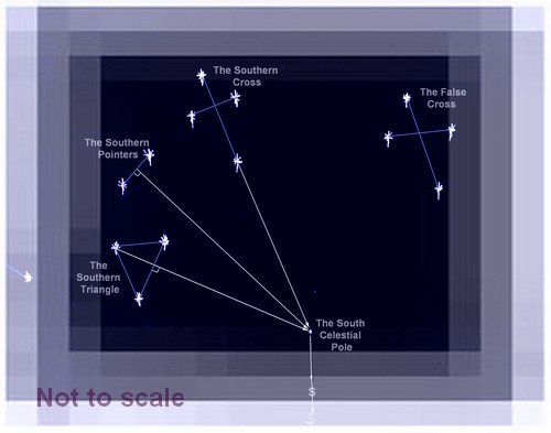
Crux; the Southern Cross a constellation seen in the southern hemisphere.
D Navigation Terms.
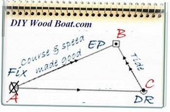
Dead
reckoning; determining a
position by plotting courses and speeds from a known position.
Declination;
the
angular distance to
a point on the celestial sphere measured north and south from the
celestial
equator along the hour circle.
Deviation; the compass errors caused by metallic o magnetic objects on board the vessel.
Digital Selective Calling (DSC)
Dip;
a correction to be
applied to sextant
attitudes to compensate for height of eye above sea level.
Doldrums;
the
Inter-tropical
Convergence Zone (or ITCZ) a belt of very still air between 5 degrees
north and
5 degrees south of the equator.
Drift;
the speed in knots of
the effect of current or tide on a
vessel's progress.
Drying height; the height above chart datum, on a chart, of any areas which are uncovered at low water.
DSC Digital Selective Calling
Duration of tide; the time between high an low water, normally just over 6 hours.
Books
E Navigation Terms.
Ebb;
out-flowing tide.
Electronic logs or E log
books; a
method of standardising the keeping of logs digitally on commercial
vessels.
Electronic
charts; there
are two different
types see Vector charts and Raster marine charts.
ENT;
, Evening Nautical
Twilight.
EP;
Estimated Position, the
DR plus the effects of
current.
Ephemerals;
a published collection
of tables giving
coordinates for astronomical bodies for specific times.
Estimated
Position;
a DR position which has
been adjusted to
allow for Set and Drift.
ETA;
estimated time of
arrival.
Equator; an imaginary circle around the earth, halfway between the north and south poles.
F Navigation Terms.
Fathom;
an old fashioned unit of
measurement to measure depth,
approximately equal to 6 feet or 1.8 meters.
Flood;
incoming tide.
First
Point of
Aries;a
point on the celestial
sphere which is used as a reference point, it is in fact where the
‘Ecliptic’ and the Celestial Equator cross.
Fix;
a position verified by
reference to bearings
take off a known point such as a conspicuous land mark.
Flotsam;
the floating debris
resulting from a
shipwreck.
Forecasting Terms; used to convey specific, concise, information on weather conditions.
G Navigation Terms.
Gates
Tidal.
Geographical
Position or
GP; in
celestial navigation it
is the point on the earths surface directly beneath the Zenith, and the
bit of
the surface you are standing on is your body’s Geographical Position or
GP.
GHA,
Greenwich Hour
Angle; the
measurement of a
position, in degrees, westward from the Greenwich meridian. Read more
GMT,
Greenwich Mean
Time; now
referred to as UTC,
Coordinated Universal Time, or UT, it is the mean of the times of noon
at the
Greenwich Meridian.
GPS,
Global Positioning
System; a
system which uses
information broadcast from orbiting satellites to calculate the
longitude and
latitude of a receiving device.
Greenwich
meridian;the
Prime Meridian it
is the 0°longitude line, it is referred to as the Greenwich Meridian
because it passes through the Royal Observatory at Greenwich in the UK.
Gyrocompass; a non magnetic type of compass.
H Navigation Terms.
Hand
held,
Compass; a
small portable
compass.
Heading;
the direction in which a
vessel is pointing,
as opposed to the course made good.
HE,
Height of
Eye; the height of a sextant user’s eye above
sea level,
needed to add as a correction to a site reduction.
Height of tide;
a figure taken from the
tide tables indicating the depth
of water above the chart datum.
Horizon;
the apparent line, for
an observer where the
earth’s surface and the sky meet. Also a circle formed on the celestial
sphere by a plane tangent to a point on the Earth's surface.
Horizon
Glass;or
Horizon Mirror half
clear glass half mirror, on a sextant it allows the observer to view
the
horizon at the same time as a reflection of whatever is showing in the
Index
Mirror. Read more:
Horse Latitudes; See Doldrums and ITCZ.
I Navigation Terms.
IALA
Systems; internationally
recognised systems of buoyage
Index
mirror; the
mirror at the apex
of a sextant frame which pivots with the index arm.
Intercept;
where
two or more lines
such as LOPs cross.
International
Date
Line; the
imaginary line in the
Pacific Ocean at which the date changes. This line varies from the 180⁰
meridian to avoid populated land areas.
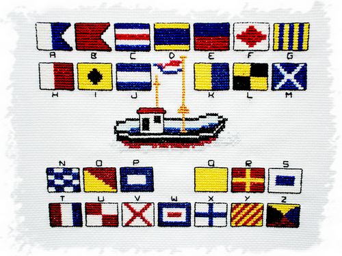
International
marine signal flags; a system of
flag shapes and designes used to communicate messages at sea.
Interpolation
Tables;
almanac tables to
estimate value between the
tabulated results.
ITCZ,
Intertropical
Convergence Zone; the
varying area
of normally still air lying approximately between 5⁰ north and south of
the equator.
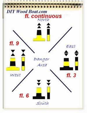
Isolated Danger Mark; buoyage marks indicating a hazard, a such as a wreck directly below the mark,
J navigation terms.
Jetsam; are objects that have been thrown overboard from a vessel, originally stuff jettisoned by a ship which was in trouble.
K navigation terms.
Knot, (Kts.); a unit of speed, nautical miles per hour.
L navigation terms.
Landfall;
the approach to or
sighting of land after an ocean
passage.
Lateral
Marks; buoyage
indicating the
edge of a safe water channel.
Latitude;
the angular distance
north or south from the
equator on the earth surface.
Leading
lights or
Range Lights; a pair of lights
deliberately placed to provide a transit along a narrow channel.
Leading
or Range
marks; transit
markers.
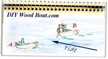
Leeway;
sideways movement of a
vessel usually caused by the
wind.
Limb;
when taking a sun or
moon sight it is difficult to guess
where the center is so the observer aligns either the top edge (Upper
Limb) or
more usually the bottom edge (Lower Limb) of the object on to the
horizon. The
sight is then corrected using the appropriate correction tables.
Line Of
Position,
LOP; a
line drawn on a chart on
which the position of the vessel must lie. The line deduced from either
a
compass bearing of a mark or a sight reduction. A minimum of two or
preferably
more are necessary to establish a fix.
Local
Noon;
the time when the sun
reaches its highest
altitude at your position and is directly north or south of you. it
will then
be at your Zenith and its GHA will correspond to your longitude.
Local time;
solar
time at your
position.
Local
Hour
Angle, LHA; the angular distance
of an observed celestial object to the west of the observers meridian.
Localized weather
phenomena; alterations made to the
prevailing weather by local
topography. Log;
an instrument used to
calculate speed and
distance travelled, through the water.
Log
book;
a book in which the
navigator records data
about the vessels progress
Longitude;
the angular distance
east or west from the
Greenwich or Prime Meridian (0⁰) on the earth’s surface.
Lower limb; see Limb. LOP; see Line of Position.
M navigation terms.
Magnetic
Compass; a
device used for
navigation which aligns with the earths magnetic field thus indicating
th
direction of magnetic north.
Magnetic
bearing; a
baring taken from a
magnetic compass.
Magnetic
north; the
northerly position of
the earths magnetic field, this is varies from the True North.
Making;
used to denote progress,
as in making way or a rising
tide as making.
Mark;
a fixed buoyage
indicator.
Mercator
projection; a method for
representing the spherical globe as a flat map with lines of latitude
and
longitude intersecting at right angles. Devised by Geradus Mercato in
1569.
Meridian; a line of longitude, the imaginary great circles on the surface of the earth which converge at the poles and have their center at the center of the earth.
N navigation terms.
Nautical Almanac;
see Almanac.
Nautical
mile; a
unit of distance that is
equal to 1/60 of a degree as measured along a line of longitude at the
latitude
of the distance to be measured.
Navigation;
the process of plotting
and directing the
course of a vessel.
Neaps;
the lowest tides in the
tidal range,
occurring when the sun and moon are in quadrature.
North
Magnetic
Pole; the
northerly point toward
which a compass' needle always points, the north of the earth’s
magnetic
field as opposed to the geographic north pole
North
Star;
see Polaris.
Notices to Mariners; updates and corrections to chart data.
O
P
Parallax;
the apparent differences
in the positions of
objects viewed along different lines of sight.
Passage
plan; a
written plan of a
proposed voyage.
Pilot
book;
a guide book giving
details of coastlines and
harbours and sailing directions.
Pilotage
plan; a
navigation plan for a
passage.
Plotting
Sheet;
a paper sheet separate
from the cart where a
navigator can plot his LOPs and the vessels course.
Position
line;
see LOP.
Position fix;
see
Fix.
Polaris;
is the pole star of the
Northern Hemisphere
it is located almost directly above the true position of due north
Ptolemy; Claudius Ptolemaeus, c. AD 90 to c. 168 a Roman mathematician, astronomer, geographer, possibly of Greek or Egyptian origin.
Q
Quadrant; a precursor to the sextant as an instrument used to measure altitudes up to 90° or one quarter of a circle, hence the name. First proposed by Ptolemy as an improvement on the astrolabe.
R
Range; the
distance at which a light or
mark can be seen from
sea level. Also the difference between the height of low water and high
water.
Range
Markers, or
Transits; marks or lights which
when in line indicate a safe channel.
Raster
marine
charts; electronic
charts which
conform to IHO specifications are produced by scanning a paper charts.
Rhumb
line; a
course sailed using a
constant compass course. An imaginary line drawn on a chart which
crosses all
the meridians at a constant angle.
Rule
of
Twelfths; a
method for making
quick estimations of tidal height. See also Rule
of
tenths.
Running fix;
advancing
a LOP or
previous line of position forward to a current line of position. A fix
based on
two separated bearings of the same fixed object and the distance run
between
the bearings.
Navigation terms
S navigation terms.
Safe
water
Mark; one
which, indicates that
there is safe water for navigation is all around the mark
Secondry port;
in
the Tide Tables
this is a port where the details have to be worked out in relation to a
Standard Port.
Sector
Lights; light
emitted from a
single position which will show up as either red, white or green
depending on
the angle of the observer, designed to indicate a safe navigational
area.
Semi-diurnal;
occurring
twice
per day.
Set; the
direction towards which a
Tide or Current is flowing.
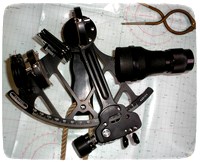
Sextant;
an instrument used to
measuring angular
distances, like the altitude of the sun, moon and stars for navigation.
Sidereal
Hour Angle
(SHA); the
angular distance of a
star from the First Point of Aries.
Slack
water;
the interval at high and
low water where the
stream ceases momentarily before changing direction.
Snellius construction;
a method for
combining three compass bearings to obtain a position fix, one where
magnetic
variation and deviation need not to be taken into account.
Solid state compass;
Sounding;
a method of measuring
the depth of
water.
Soundings;
water shallow enough to
allow depth to be
measured by lead line.
Southern
Cross;
see Crux.
South
Magnetic Pole;
the southerly point
toward which a compass'
needle always points, the south of the earth’s magnetic field as
opposed
to the geographic south pole.
Special
Marks; buoyage
indicators of
special areas or objects mentioned on the charts or in other nautical
and
publications.
Speed Made Good, SMG;
the actual
speed over the ground as opposed to through the water.
Spring tide;
where
the rise and fall
or range of the tide is greatest, occurring around the time of the full
and new
moon.
Standard port;
a
port for which the
Tide Tables give full details and from which Secondary Port details con
be
extrapolated. Strait;
a narrow channel of
water connecting two
larger bodies of water.
Synoptic charts; a diagrammatic representation of weather data, summarised and overlaid on a chart.
T navigation terms.
Taking
off; the
opposite of
Making.
Terrestrial sphere;
the
earth.
Tidal
Diamonds; a
method for showing
tidal information on a nautical chart.
Tidal
race;
where the tidal stream
creates confused and
sometimes dangerous water.
Tidal
stream;
the horizontal flow of
the tide.
Top
mark;
the distinctive shape on
top of a
buoy.
Track; the
plotted course of a
vessel.
Trade
winds;
steady easterly winds
that blow through the
tropics and subtropics.
Transit;
two fixed objects in
lined up by an
observer.
Transit
fix;
a method of lining up
charted objects to
obtain an LOP.
Transit
Markers; see
Range
Markers.
True north; geographic north as opposed to magnetic north
U navigation terms.
Universal Coordinated Time, UTC or UT; the time at the Greenwich or 0⁰ meridian, GMT, Zulu time.
V navigation terms.
Variation;
the angle between True
North and Magnetic
North.
Vectors,
tidal for
plotting EPs.
Vector charts; a type of electronic chart.
W navigation terms.
Way
Points; navigation
positions as
entered in a GPS.
Westerlies;
are the prevailing
west-to-east winds of the middle
latitudes of both hemispheres on Earth.
X navigation terms.
Y navigation terms.
Z navigation terms.
Zenith;
the point directly above
the observer’s
head.
Zenith
distance; the
angular distance
between a celestial object and the observer’s zenith,
Zone Time,
ZT; the
clock time within
each meridian.
Zulu time; see Universal Coordinated Time.
I will be adding more Navigation Terms when I think of them. In the mean time, if there is a navigation term you would like to know more about let me know using the comment form below.

You might like these
Maritime Weather Patterns
Global weather patterns influence your local marine conditions, understanding how these work will help you to interpret forecasts, help to keep you safe and your boating enjoyable.
Digital Selective Calling (DSC)
Digital Selective Calling
Automatic Identification System AIS
Automatic Identification System AIS
Weather Sayings
Weather sayings, worth remembering, sailors use phrases, expressions and idioms for short term forecasting, many have scientific explanations.
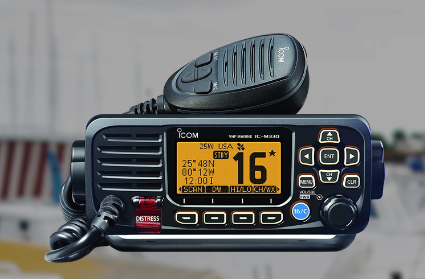
VHF Marine Radio
Description of VHF Marine Radio Equipment for the average boater, types of transceiver, range and restrictions.
Tides, how they are caused and predicted.
Tides, tidal streams, sea level predictions and marine currents and what the leisure boater should know about Tide tables, charts coastal height prediction data.
Tide Gates and Navigation.
Tide gates, currents, overfalls and tide races what to watch out for when planning coastal navigation.
Tidal Stream Vectors for Boat Navigation.
Tidal stream and currents, how they affect boat navigation, estimating position and determining course to steer
Southern Cross, Navigating by the Stars in the Southern Ocean.
How to use The Southern Cross as a pointer to find the South Celestial Pole.
Rule of Twelfths for Quick Tidal Estimates
The rule of twelfths and the rule of tenths are easy rule of thumb calculations for quickly working out the approximate tidal stream and tide height from marine tide table predictions.
Site Index, of DIY Wooden Boat Articles.
Site Index, alphabetical list of wood boat diy guides, for building, fixing up and maintaining wooden boats.
DIY Wood Boat Link Library
DIY Wood Boat Link Library, a list of online links of value and interest to Wooden Boat enthusiasts.
Weather Forecasting Terms and Beaufort Scale.
Forecasting terms explained, the Beaufort Scale and other meteorological terms used in marine forecasts
Signaling Flags and their Meanigs.
International code signaling flags and their meanings for use at sea.
Boating Terms and expressions.
Common Boating Terms expressions and their meanings that Every Wooden Boat Enthusiast Ought to Know.
Miscellaneous Boating Questions Answers
Miscellaneous Boating Questions Answers for your Wooden Boat problems
Recent Articles
-
Reader's Boat Photos
Aug 23, 25 09:08 AM
 Gallery of Readers uploaded Photos
 -
The Sliding Bevel
Jun 19, 25 02:52 AM
 By Robin Gates
The Sliding Bevel: A Boatbuilder’s Tool for Precision
For angles other than the perpendicular of the try-square and 45 degrees of a mitre-square, the essential measuring tool is a slidin…
-
Winter Bilge Issues
Jun 18, 25 07:34 AM
 By Adrian Morgan
Winter Bilge Issues: Can a Classic Boat Spend Too Long Ashore?
Beware the score of too long ashore, Adrian Morgan warns us…
Continue reading "Winter Bilge Issues"
You might like these
Cold Water Boating
Safety precautions for cold water boating and winter sailing
How to Mooring Your Boat.
Avoid embarrassment when Mooring and Docking, learn how to get it right safely with the correct lines and at least appear competent.
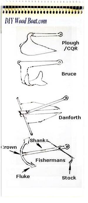
Anchor Types
Anchor types, how to choose the type, size and style of ground tackle, chain and rode to anchor your boat safely.
Anchoring Techniques
Anchoring techniques, best practices to ensure the safety of you and your boat, and how to retrieve a snagged hook.
Boat Winches
Boat Winches, sheet, anchor, halyard and trailer winches for Wooden boats
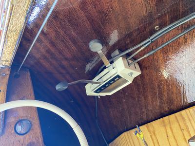
Wind Vane Self Steering Gear for Sailboats
Wind vane self steering, what you need to know if you want to make your own windvane for singlehanded and shorthanded sailing on your wooden sailboat.
Wooden Cabin Cruisers
Building or restoring cabin cruisers Tips and suggestions for fitting out and equiping your wood boat.
Green Boating with Uncle Charlie.
Green boating for my Uncle Charlie is nothing to do with any "trendy environmental initiatives" but just an old fashioned, frugal way of living and a love of sailing old wooden boats.
Marinas with Uncle Charlie.
Uncle Charlie and family avoid marinas not only because of the cost but because there is always an audience.
The Tao of Wooden Boat Sailing and Boat Building.
For my Uncle Charlie the Tao of boating isn't a consciously practiced Zen, neither does he regard himself as spiritually enlightened yet he has a self contained harmony a Yin Yang balace.


This work is licensed under a Creative Commons Attribution-ShareAlike 2.0 UK: England & Wales License.
I am perfectly aware that the majority of Wooden Boat aficionados are sensible folk.
However, I need to point out that I am an amateur wooden boat enthusiast simply writing in order to try to help other amateur wooden boat enthusiasts.
And while I take every care to ensure that the information in DIY Wood Boat.com is correct, anyone acting on the information on this website does so at their own risk.