- Home
- Your Boats
- Tides
Tides; Causes, Predictions and Effects.
The tides are the regular, predictable changes in sea level which every boater must know about.
It is vitally important, for coastal Navigation, to understanding and be able to predict tidal effects.
Why does the sea rise and fall?
The rise and fall of sea levels are caused by the gravitational pull of the sun and moon and are also affected by centrifugal forces generated by the earth’s rotation.
The effect is subject to the relationship between the earth, the moon and the sun at any given time.
The moon being closer to the Earth has a greater influence on the oceans than the sun.
As the moon rotates around Earth a bulge in the seas occurs beneath the moon where its gravitational pull is greatest.
Meanwhile, on the opposite side of the globe, where the moons pull is negative the centrifugal force of the earth’s rotation creates a second bulge away from the moon.
These are the high tides, between which are the low waters.
It is also why there are normally two tides every 24 hours and 50 minutes, which is the time it takes for the moon to rotate around Earth.
And it is that extra 50 minutes which mean the times alter from day to day.
However these ‘lunar tides’ are modified by the ‘solar-tides’ caused by the gravitational pull of the sun.
It is this reinforcing or partially canceling out of the ‘lunar-tide’ which causes springs and neaps.
Tidal Phases
Most coastlines experience a high water every 12 hours 25 minutes with a corresponding low water in between, these are known as ‘semi-diurnal’.
However these are also influenced by the shape of the coastline and sea bed.
Coastal geography can, in some places, cause double high waters, or double low waters.
There are even some coasts which have only one, ‘diurnal’ phase per day and places where it can vary between ‘diurnal’ and ‘semi-diurnal’.
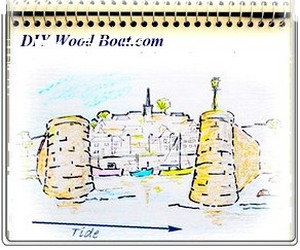
As the sea level rises (floods) and falls (ebbs) it produces what are known as tidal streams.
'Slack water’ is the interval at high and low water where the stream ceases momentarily before changing direction.
Springs’, the highest high waters and corresponding lowest low waters occur a day or so after the full moon.
‘Neaps’, where the range is least, occur shortly after the Moon is in its First and Third Quarter.
The time between high and low water is approximately the same whether it’s a neap or spring tide.
So, this means that at springs the water has to rise further so the ‘stream’ must be faster, than at neaps.
The largest tidal ranges of the year, the ‘equinoctial-springs’, occur shortly after the new and full moon closest to the equinoxes.
The spring or ‘vernal’ equinox is usually around the 21st of March, and the autumnal equinox around the 23rd of September.
Predictions and Tables.
As
the rising and falling of the ocean is caused by the
gravitational influences of the Earth-Moon-Sun and as the behavior of
their
orbits are known extremely accurately, so their influence on the oceans
can be
predicted.
However, as the topography also has an influence, each location has to have its own record of sea level behavior over time using a tide-gauge.
By combining all this information, fairly accurate predictions for any date in the future, at a given location, can be made.
However, there are factors such as changes in seabed, rises in sea level, as well as the weather that will affect tidal behavior at any given time.
Tables generally give a list of the maximum and minimum sea levels heights and times for each day.
However, the heights given are related to a chart datum.
To calculate the actual depth of water at a given point, add the charted depth to the height in the tables.
Areas which dry will be shown on the chart as having negative values these should be subtracted from the tabulated height.
You must always check that your charts and tables are based on the same datum.
The most commonly used datums are ‘lowest astronomical tide’ and ‘mean lower low water’.
N. O. A. A. In the United States uses the mean-lower-low-water, MLLW, as its datum.
This means that some tidal states may show as having a negative height.
Most other national hydrographical charting agencies use the lowest-astronomical-tide (LAT) as their datum.
The advantage of using LAT is that all tabulated heights are shown as positive numbers.
BooksUnpredictable Tides.
It should be remembered that the tables for a given location are predictions based on average historical data.
They cannot allow for unpredictable conditions.
There are other factors which contribute to the rise and fall of the sea level.
Meteorological effects such as wind and atmospheric pressure can also contribute.
A storm surge for instance can add several meters to the predicted water level.
Wind can speed up or retard the time of high or low water depending on whether it is with or against the tidal stream.
Some Extremes.
The most famous example of an extreme tidal range is that of the Bay of Fundy, where the difference between high and low water, the range, can exceed 16 meters.
This is closely followed by the Bristol Channel where the extreme range at Avonmouth is just over 15 meters.
While on the other hand areas like the Mediterranean Sea and the Baltic Sea have no significant rise and fall except close to their narrow entrances.
However, fast streams can occur anywhere where tide flowing from one large area of water to another has to pass through a narrow channel.

Books
You might like these
Maritime Weather Patterns
Global weather patterns influence your local marine conditions, understanding how these work will help you to interpret forecasts, help to keep you safe and your boating enjoyable.
Digital Selective Calling (DSC)
Digital Selective Calling
Automatic Identification System AIS
Automatic Identification System AIS
Weather Sayings
Weather sayings, worth remembering, sailors use phrases, expressions and idioms for short term forecasting, many have scientific explanations.
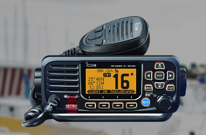
VHF Marine Radio
Description of VHF Marine Radio Equipment for the average boater, types of transceiver, range and restrictions.
Tide Gates and Navigation.
Tide gates, currents, overfalls and tide races what to watch out for when planning coastal navigation.
Tidal Stream Vectors for Boat Navigation.
Tidal stream and currents, how they affect boat navigation, estimating position and determining course to steer
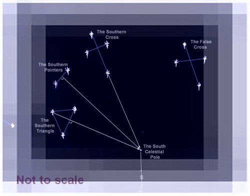
Southern Cross, Navigating by the Stars in the Southern Ocean.
How to use The Southern Cross as a pointer to find the South Celestial Pole.
Rule of Twelfths for Quick Tidal Estimates
The rule of twelfths and the rule of tenths are easy rule of thumb calculations for quickly working out the approximate tidal stream and tide height from marine tide table predictions.
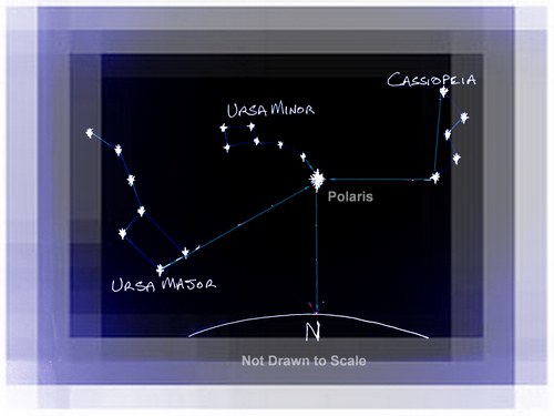
Polaris the Navigator's Star
How to use Polaris to determine the direction of north, probably the oldest form of celestial navigation in the northern hemisphere.
Recent Articles
-
Reader's Boat Photos
Aug 23, 25 09:08 AM
 Gallery of Readers uploaded Photos
 -
The Sliding Bevel
Jun 19, 25 02:52 AM
 By Robin Gates
The Sliding Bevel: A Boatbuilder’s Tool for Precision
For angles other than the perpendicular of the try-square and 45 degrees of a mitre-square, the essential measuring tool is a slidin…
-
Winter Bilge Issues
Jun 18, 25 07:34 AM
 By Adrian Morgan
Winter Bilge Issues: Can a Classic Boat Spend Too Long Ashore?
Beware the score of too long ashore, Adrian Morgan warns us…
Continue reading "Winter Bilge Issues"


This work is licensed under a Creative Commons Attribution-ShareAlike 2.0 UK: England & Wales License.
I am perfectly aware that the majority of Wooden Boat aficionados are sensible folk.
However, I need to point out that I am an amateur wooden boat enthusiast simply writing in order to try to help other amateur wooden boat enthusiasts.
And while I take every care to ensure that the information in DIY Wood Boat.com is correct, anyone acting on the information on this website does so at their own risk.