- Home
- Your Boats
- Celestial Navigation
Celestial Navigation, an Introduction.
Having
a working knowledge of Celestial Navigation is often put forward as a
back up for GPS and all those other electronic aids we rely on theses
days.
Fortunately however, it
is unusual for modern equipment to go wrong.
And GPS sets are so cheap that most folk keep a spare, complete with spare batteries, in a waterproof container, just in case.
So
why
take the time and trouble to
learn about this ancient art / science?
Well one could ask why do people go to sea in small boats, climb mountains, etc?
Perhaps we all have an inbuilt need to connect to our environment or even an aspiration to the divine.
Besides, there is tremendous satisfaction from being able to truly place ourselves, not just on the surface of our little planet but within the breath-taking beauty of the heavens.
Ptolemy / Copernicus
For the purposes of celestial navigation on the surface of our planet you don't need to know about any of those crazy Copernican ideas of the universe.
As far as we are concerned the pre-Copernican, Ptolemaic notions of what we see up there are sufficient.
Of course it is always good to know what really is going on, but for now all we need is to be aware of what we can see.
And what we see up there are the Sun, Moon, Stars, and Planets marching in step across the sky.
They all rise to our east and set in the west.
Now, imagine that all these celestial bodies are on the inside surface of an immense crystal globe which encloses the earth.
And imagine that this crystal globe has an equator, north and south poles, latitude and longitude which reflect those of the earth.
Our celestial sphere now has a grid system which we can use, just like the lat and long on earth, to locate the position of celestial objects in relation to us.
The Celestial Spheres.
 The Celestial Sphere
So, now we earth bound navigators have two spheres to consider.
The first is the surface of the earth, the second is the inside surface of that imaginary crystal globe surrounding the earth.
On both spheres we use the same imaginary sets of coordinates, latitude and longitude.
We use this grid system to pinpoint the location of anything on either sphere.
The grid on the celestial sphere is a projection of the grid on the terrestrial sphere.
So if you were stood at the Earth's North Pole directly above your head would be the Celestial North Pole.
And by the same token the Celestial equator would be directly above someone stood on the earth's equator.
OK, so far so good, now it starts to get a bit complicated.
The equivalents of the terrestrial latitude lines are called lines of Declination, on the celestial sphere, while longitude line equivalents become Hour Circles, on the celestial sphere.
And where longitude, on the terrestrial sphere is measured through 180 degrees east or west of the Greenwich meridian, on the celestial sphere it is numbered from 0° all the way around to 360°.
And the 0° hour circle known as the Celestial Meridian is known as the First Point of Aries.
There is also quite a bit of strange archaic language used
in Astro
Navigation but to begin with there are a few terms which are worth
understanding.
These are to do with how you or I relate to the celestial bodies.
First is the point directly over your or my head this is known as your or my Zenith, and the bit of the surface you are standing on is your body's Geographical Position or GP.
The imaginary line running, due north or south from my or your Zenith is known as your or my own Meridian.
And the distance of any celestial body above your or my horizon is known as its Altitude, this is the angle which is measured with a sextant.
If you imagine a line from the centre of any celestial body to the centre of the earth where it passes through the surface of the earth is known as that celestial body's Geographical Position or GP.
The GP for a celestial body is measured in degrees of latitude and longitude.
The latitude measured north or south of the equator is known as its Declination.
Its longitude is measured in degrees westward from the Greenwich meridian and is known as the Greenwich Hour Angle (GHA) .
The Declination and GHA for the celestial bodies which are used for navigation can be found in the Almanac.
The Sun.
Sunrise tells us the approximate direction of east and conversely west at sundown.
And I'm sure you are more than capable of working out from that the direction of north and south.
So, you are already something of an Astro Navigator!
OK, it's not quite that simple as that as the place the sun appears to rise from will vary slightly throughout the year.
At the equinoxes 21st of March and 23rd of September it will rise at due east and set due west.
But by 21st June the 'summer solstice' it will rise 23.5° further to the north of east then by 22nd December the winter solstice it will be 23.5° south of east.
This is because the earth's axis is tilted by approximately 23.5° and remains tilted in roughly the same direction throughout the year, and it is also why we have seasons.
The rate of change is approximately 1° every four days.
Now don't rush out to buy a sextant, you can make a rough measurement of the suns angle using your hand.
Stretch your arm out
towards the horizon, use your clenched fist as a rough measuring
device.
Your fist will give you a rough angle of 10° this can be subdivided by each finger being the equivalent of 2°.
So if you want to find due east on the morning of the 1st March, (20 days before the equinox) you know that the sun will be rising 5° south of east, so you need to measure half a fist to the north, of where it rises, to find due east.
OK, so that tells you where east and therefore all the other compass directions are but it doesn't tell you where you are.
But what we have learned so far is that the GP of the sun and therefore is Declination changes throughout the year.
And, that this information is predicted for us in the Nautical Almanac.
The Longitude Problem.
So how, using astro navigation, do you
find your
position?
Well let's stay with the sun for now as it is the easiest celestial body to find and consider the ocean navigators bedrock, the Noon Sight.
The reason for taking the Noon Sight is to determine the exact time when the sun has risen to its highest point in the sky.
This is known as your Local Noon.
At your Local Noon the
sun is directly north or south of you depending on where you are on the
globe.
This means that its Celestial Meridian will correspond with your Longitude at that particular moment in time.
Now longitude is measured in degrees around the globe but one circuit of the globe is also equal to one solar day.
So if you have an accurate watch (chronometer) set to UT (Universal Time) or GMT as it used to be called, the difference between your Local Noon and UT Noon can be converted into degrees and distance west or east of the Greenwich meridian.
The distance of a body's GP from the Greenwich Meridian is its Greenwich Hour Angle (GHA).
So for every hour your local noon is after UT noon you are 15° further west of the Greenwich meridian and conversely every hour your local noon is before noon UT you 15° further east.
Unfortunately the sun isn't a very good time keeper, it can be as much as 20 minutes slower or faster than UT.
And any error in time will give us an error in longitude.
This is why we need that Almanac, it will give us the UT or Greenwich Mean Time that the sun reaches its highest point at Greenwich, for every hour of the day and for every day of the year.
This is the sun's Greenwich Hour Angle (GHA).
We can then use that time as our starting point.
And the need for accuracy is also why the sextant and an accurate watch are so important to celestial navigation.
In practice there are minor corrections which need to be applied but these only require some simple addition and subtraction and there are simple forms which can be used to make it even easier.
For now, it's the concept we are concerned with.
But regardless how accurate you are or how simple it is, having only one coordinate won't tell us where we are, we could be anywhere along that meridian line between the north and south poles.
The lack of an accurate way of telling the time is why sailors in days of yore had problems determining their longitude.
What they were able to do, with considerable accuracy, was work out their latitude.
Finding Latitude.
 Finding Latitude
So to plot our position on that line of longitude we need
to know our latitude.
The Declination,
if you
remember, is the celestial spheres equivalent of our terrestrial
latitude.
The almanac will tell us
the declination of the sun for our particular date and time.
Now if the sun were
directly overhead our declinations would be the same and we would have
our latitude.
However, that is
unlikely, usually we are going to be either north or south of the sun.
So to arrive at our
latitude, we begin by measuring the angle between our horizon and the
object, the sun, with our sextant.
This angle is the sun's Altitude.
However this angle is
one we are measuring on the surface of the earth.
The suns declination is
measured from the center of the earth.
To get from altitude to
declination we need what's known as the Zenith Distance,
this is simply 90° minus the Altitude.
If
we now add or subtract the sun's declination, which we got from the
almanac, to or from that zenith distance and we have our Latitude!
Why did I say add or
subtract?
Well, that will depend
on whether declination is north or south.
There are also other corrections, which in practice have to be taken into consideration but for now we are just looking at the concept.
Navigating by the Stars.
Just as we can use
the sun for quick navigational reference during the day at night we can
use the stars.
For those of us in the northern hemisphere (if there is a clear sky)
Polaris is a major asset for astro navigation.
The star Polaris
never rises or sets lies, as near as damn it, at the Celestial North
Pole directly above the Terrestrial North Pole, and it is easily found.
Learning to identify Polaris in the night sky is a superb introduction to the art of celestial navigation.
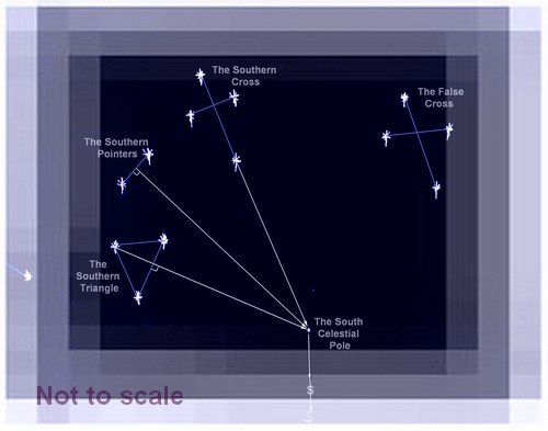
For
the navigator in the southern hemisphere there is no equivalent star
but the position of the south celestial pole can be found using the pointer
stars, the most famous of which is the Southern Cross.
Using Polaris
to find your latitude is, like
the Noon Sun Sights relatively simple.
However, when using a sextant you will need to be able to see
the
horizon as well as the star.
So sights are taken at dawn or dusk, when both are visible.
Finding your latitude and longitude using Polaris requires a
similar process to that of the Noon Sun sight, except that it does
require a few more simple corrections because Polaris is never
precisely at the North Celestial Pole.
In fact Polaris makes a very small circuit around North Celestial Pole.
But
despite that tiny discrepancy Polaris is always more or less on the
observers Meridian whereas the sun is only on your Meridian at noon.
All the other stars circle around the Celestial Poles, how
they appear to circle and whether or not they set will depend on your
latitude.
Travelers from time immemorial have been using the stars to help them
find their way.
The Pacific Islanders were especially adept at using star patterns for
navigation.
And they are just as useful for today's navigator, fortunately
for us we do not have to keep all the relevant information in our heads
as did those Polynesians, all we need is in the Almanac.
However, if the Almanac were to give us the GHA of every star, the book
would be too large and heavy for the average cruiser.
So, what the Almanac gives us is its Sidereal Hour Angle (SHA).
The SHA is the star's distance from the First Point of Aries, (represented by the sign of the ram) which using simple worksheets and some simple maths we can then convert.
So, the almanac only needs to tabulate the movement of this one position then by giving us the angular distance to all the navigational stars, we can easily calculate the GHA for any star at any time.
 So, what is this
First Point of Aries?
So, what is this
First Point of Aries?It is a point on the celestial sphere which is used as a reference point, it is in fact where the 'Ecliptic' and the Celestial Equator cross one another.
However, the relevance for celestial navigation is that, as far as we are concerned, all the stars remain in the same relative positions to it and each other through out the year.
The Planets.
The
advantage of using the stars for navigation is that as they revolve
around the celestial sphere they remain in the same relationship to
each other, which is why they used to be known as the 'Fixed Stars'.
The
planets however move, but their movements are predicted in the almanacs
so we can tell precisely where each body is for any second throughout
year, these used to be called the 'wandering objects'.
While
the astronomers using their telescopes can count innumerable planets
the ones we are interested in are those which are easily visible to the
naked eye.
Venus, Mars, Jupiter, and Saturn plus of course the Sun are the only ones used for navigation unless we include the Moon with this group.
The method used to reduce an observation of a planet is similar to taking a sun sight, except that as you also need to see the horizon to measure the altitude this must be done at twilight.
The Moon, if I can be forgiven for including it here under Planets, can also be used for navigation.
However because it is so much closer to the earth than the other object we use, many more 'corrections' have to be made when reducing the sight.
Anyone who has read Joshua Slocum's account of his sail around the world will know that he used Moon sights as his main way of telling the time, his only clock was an old wind up alarm clock with no minute hand.
affiliate linksThe Sextant.
 Sextant
A reasonable quality sextant such as the one I bought years ago will cost about the same as four or five hand held GPS sets.
There are some much cheaper plastic sextants on the market which I am led to believe are just as accurate.
I am also led to believe (never having used one) that care must be taken over the storage of the plastic ones as they are much more susceptible to developing errors, so might need adjusting more often.
The sextant as I'm sure you are aware by now is used to measure the angle between the horizon and a celestial body.
It can also be used to measure the any sighted angle, such as the angular distance between two landmarks or the height of a lighthouse, when coastal sailing.
Like any good magic
trick it's all done with mirrors.
It is called a sextant because the calibrated arc is one sixth of a circle 60° , however because of the mirrors it can actually measure angles up to 120° .
The frame of the sextant looks a bit like a slice of pizza.
The scale, the curved bottom part is fixed to the frame as is the telescope and the Horizon Mirror and the shades.
The Index Mirror pivots at the apex of the frame and is attached to the index arm so they both move together.
At the other end of the Index Arm is the measuring micrometer.
The fixed Horizon Mirror is only half mirror the other half of it is clear glass.
It is fixed so that when you look through the telescope one half of the view is straight ahead the other half is the reflection of whatever is showing in the Index Mirror.
When taking a sight the index mirror is adjusted so that the celestial object is reflected down into the mirror side of the horizon mirror while the horizon is visible through the clear side.
The shades are there to protect your eyes when taking Sun Sights.
The micrometer is there to enable very precise angular adjustments and measurements to be made.

How reflecting
instruments -- like sextants -- work
demo wikipedia commons
Previous posts
See What Others Have Posted
Azimuth
Dear,
I was going to look up "Azimuth Angle"(Z) but found only "Azimuth".
As far as I know Azimuth (Zn) is always measured from true North clockwise …

Thanks
to the GPS you know where you are, you can check your position against
the sextant, see the difference, note any little errors, gradually
correct them and become almost as good s the GPS itself.
(Bernard
Moitessier)
You might like these
Maritime Weather Patterns
Global weather patterns influence your local marine conditions, understanding how these work will help you to interpret forecasts, help to keep you safe and your boating enjoyable.
Digital Selective Calling (DSC)
Digital Selective Calling
Automatic Identification System AIS
Automatic Identification System AIS
Weather Sayings
Weather sayings, worth remembering, sailors use phrases, expressions and idioms for short term forecasting, many have scientific explanations.
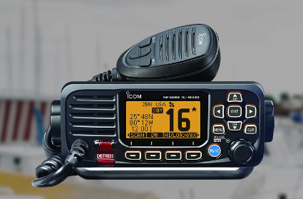
VHF Marine Radio
Description of VHF Marine Radio Equipment for the average boater, types of transceiver, range and restrictions.
Tides, how they are caused and predicted.
Tides, tidal streams, sea level predictions and marine currents and what the leisure boater should know about Tide tables, charts coastal height prediction data.
Tide Gates and Navigation.
Tide gates, currents, overfalls and tide races what to watch out for when planning coastal navigation.
Tidal Stream Vectors for Boat Navigation.
Tidal stream and currents, how they affect boat navigation, estimating position and determining course to steer
Southern Cross, Navigating by the Stars in the Southern Ocean.
How to use The Southern Cross as a pointer to find the South Celestial Pole.
Rule of Twelfths for Quick Tidal Estimates
The rule of twelfths and the rule of tenths are easy rule of thumb calculations for quickly working out the approximate tidal stream and tide height from marine tide table predictions.

Recent Articles
-
Reader's Boat Photos
Aug 23, 25 09:08 AM
 Gallery of Readers uploaded Photos
 -
The Sliding Bevel
Jun 19, 25 02:52 AM
 By Robin Gates
The Sliding Bevel: A Boatbuilder’s Tool for Precision
For angles other than the perpendicular of the try-square and 45 degrees of a mitre-square, the essential measuring tool is a slidin…
-
Winter Bilge Issues
Jun 18, 25 07:34 AM
 By Adrian Morgan
Winter Bilge Issues: Can a Classic Boat Spend Too Long Ashore?
Beware the score of too long ashore, Adrian Morgan warns us…
Continue reading "Winter Bilge Issues"
You might like these
Maritime Weather Patterns
Global weather patterns influence your local marine conditions, understanding how these work will help you to interpret forecasts, help to keep you safe and your boating enjoyable.
Digital Selective Calling (DSC)
Digital Selective Calling
Automatic Identification System AIS
Automatic Identification System AIS
Weather Sayings
Weather sayings, worth remembering, sailors use phrases, expressions and idioms for short term forecasting, many have scientific explanations.
VHF Marine Radio
Description of VHF Marine Radio Equipment for the average boater, types of transceiver, range and restrictions.
Tides, how they are caused and predicted.
Tides, tidal streams, sea level predictions and marine currents and what the leisure boater should know about Tide tables, charts coastal height prediction data.
Tide Gates and Navigation.
Tide gates, currents, overfalls and tide races what to watch out for when planning coastal navigation.
Tidal Stream Vectors for Boat Navigation.
Tidal stream and currents, how they affect boat navigation, estimating position and determining course to steer
Southern Cross, Navigating by the Stars in the Southern Ocean.
How to use The Southern Cross as a pointer to find the South Celestial Pole.
Rule of Twelfths for Quick Tidal Estimates
The rule of twelfths and the rule of tenths are easy rule of thumb calculations for quickly working out the approximate tidal stream and tide height from marine tide table predictions.


This work is licensed under a Creative Commons Attribution-ShareAlike 2.0 UK: England & Wales License.
I am perfectly aware that the majority of Wooden Boat aficionados are sensible folk.
However, I need to point out that I am an amateur wooden boat enthusiast simply writing in order to try to help other amateur wooden boat enthusiasts.
And while I take every care to ensure that the information in DIY Wood Boat.com is correct, anyone acting on the information on this website does so at their own risk.