- Home
- Cruising
- Marine Weather
- Forecasting Terms
Forecasting Terms and the Beaufort Scale.
The Beaufort Scale is just one of the forecasting terms still in use by marine forecasters today.
This scale and a number of other terms are used to convey specific, concise, meanings to help sailors estimate the wind speed and strength, sea state and forecast predictions
The Beaufort Wind Force Scale.
The Beaufort Scale was created by Admiral Sir Francis Beaufort in 1805, his wind strength and sea state numbers are among the forecasting terms still in use today.
|
|
|
|
|
|
|
|
|
|
|
|
|
|
|
|
|
|
|
|
|
|
|
|
|
|
|
|
|
|
|
|
|
|
|
|
|
|
|
|
|
|
|
|
|
|
|
|
|
|
|
|
|
|
|
|
|
|
|
|
|
|
|
|
|
|
|
|
|
|
Wind descriptions.
Marine Weather Forecasting Terms used to describe how the wind is forecast to behave.
|
|
|
|
|
|
|
|
|
|
|
|
Forecasting Terms for Visibility.
These Forecasting Terms are used to describe viability quite specifically.
|
|
|
|
|
|
|
|
|
|
|
|
Time periods.
|
|
|
|
|
|
|
|
|
Pressure tendency.
|
|
|
|
|
|
|
|
|
|
|
|
|
|
|
|
|
|
Speed of pressure systems movement.
These Forecasting Terms are used to describe the predicted movements of pressure systems.
|
|
|
|
|
|
|
|
|
|
|
|
|
|
|
NATIVE ASYNC


Recent Articles
-
Wooden Boat Events 2024
Apr 14, 24 05:15 AM
Wooden Boat Events 2024 calendar, traditional and classic boat festivals and regattas from around the world
“We clear the harbor and the wind catches her sails and my beautiful ship leans over ever so gracefully, and her elegant bow cuts cleanly into the increasing chop of the waves.
I take a deep breath and my chest expands and my heart starts thumping so strongly I fear the others might see it beat through the cloth of my jacket.
I face the wind and my lips peel back from my teeth in a grin of pure joy.”
(L.A. Meyer)
You might like these
Miscellaneous Boating Questions Answers
Miscellaneous Boating Questions Answers for your Wooden Boat problems
A Glossary of Navigation Terms
Definitions of navigation terms used in marine navigation
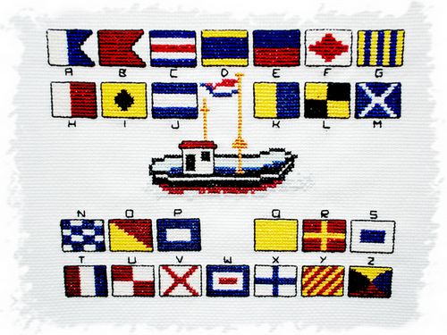
Signaling Flags and their Meanigs.
International code signaling flags and their meanings for use at sea.
Site Index, of DIY Wooden Boat Articles.
Site Index, alphabetical list of wood boat diy guides, for building, fixing up and maintaining wooden boats.
Boating Terms and expressions.
Common Boating Terms expressions and their meanings that Every Wooden Boat Enthusiast Ought to Know.
Recent Articles
-
Wooden Boat Events 2024
Apr 14, 24 05:15 AM
Wooden Boat Events 2024 calendar, traditional and classic boat festivals and regattas from around the world -
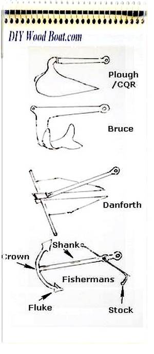
14’ 1956 Chris Craft, side rail how should it be attached?
Apr 12, 24 03:38 AM
 Removing the old side rail most of the screws went between the top deck/skin 1/4” plywood and the side of the hull. See photo, is this correct? I would
 -
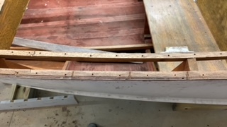
How to laminate plywood on the hull
Apr 10, 24 03:46 AM
I'm working on replacing the bottom of 18' 1969 runabout that has a deep-V plywood hull. It had a 1/2 mahogany plywood bottom that they somehow got to


This work is licensed under a Creative Commons Attribution-ShareAlike 2.0 UK: England & Wales License.
I am perfectly aware that the majority of Wooden Boat aficionados are sensible folk.
However, I need to point out that I am an amateur wooden boat enthusiast simply writing in order to try to help other amateur wooden boat enthusiasts.
And while I take every care to ensure that the information in DIY Wood Boat.com is correct, anyone acting on the information on this website does so at their own risk.